Thursday, September 28, 2023

The Cova Gran of Santa Linya

Cova gran de Santa Linya

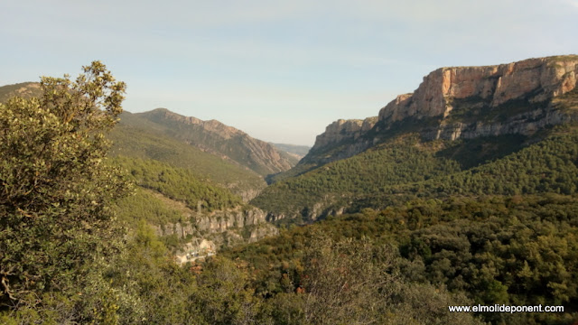
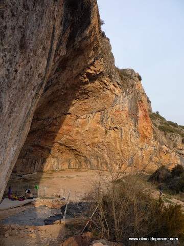
This is an immense shelter of great chromatic beauty, covering 2800 m2 that are disputed by climbers and archaeologists, just as the last Neanderthals and the first Sapiens did thousands of years ago.

According to climbers, it is the best place in the world for sports climbing, as it has a high concentration of challenging routes on high-quality limestone rock. There are 40 routes rated above grade 8, including 7 rated at grade 9. The fact that it often appears in specialized magazines and the frequent presence of media climbers like Chris Sharma attracts people from all over the world, making it a significant tourist attraction for the entire area.

From an archaeological perspective, we have 9 meters of previously unknown strata, discovered in 2002, representing an unprecedented sequence of the last 50,000 years in central Catalonia. So far, according to Rafael Mora, we know that the Neanderthal and the Sapiens coexisted in this cave without biological or cultural mixing.

We hope that this time the actors playing Neanderthals have better luck!

escalando en la cova gran de Santa Linya

La Linya - the first woman of Noguera

In the 2020 archaeological excavation campaign, remains of a sapiens woman from about 14,000 years ago, from the late Upper Paleolithic period, were discovered. This finding is significant because there are few human remains from this period on the Iberian Peninsula, and it is expected to deepen our understanding of the hunters and gatherers of that time.

The archaeological information sign of Cova Gran

Translated from the Information Panels

The Cova Gran de Santa Linya is located in the middle of a very secluded small valley, formed by the Sant Miquel stream. Despite the apparent isolation of this location within the geography of Noguera, it was inhabited by two hominins: H. neanderthalensis and H. sapiens. This cavity, on the first foothills of the Pre-Pyrenees, preserves evidence of the last 50,000 years of our history.

The Cova Gran allows us to understand the changes in the ways of life of our ancestors, the ancient inhabitants of the Pre-Pyrenees of Noguera, over an extended period. The evidence of these vanished societies is part of the heritage of all citizens. It is the duty of everyone to respect it, protect it, and pass it on to future generations, as it allows us to comprehend how the experience of our human species has evolved over time.

Homo neanderthalensis

The first inhabitants of the cave were groups of Neanderthals, who intermittently settled during their seasonal movements, which defined the hunter-gatherer way of life. Among them, we find rocks made of flint and chert that they used to craft the tools they needed to obtain or transform essential resources, such as food.

Hunting mammals like deer, goats, horses, and bulls, as well as collecting plants and fruits, formed the basis of their subsistence. Fire was a constant in the organization of the social life of these groups.

Cave Engravings

Recent archaeological research has identified five sets of non-figurative engravings on the cave wall: signs, bundles of converging lines, a grouping of shapes, two small grids, and the possible schematic representation of a human figure in the shape of a "Y".

The location of these engravings in relation to archaeological occupations could correlate with the final moments of hunter-gatherer groups that frequented the cave around 10,000 years ago. On the other hand, the bundles of lines and the grids show a wide chronology, ranging from the Mesolithic to the Neolithic, while the "Y" motif is characteristic of the Neolithic.

It is not easy to interpret the meaning of these engravings, but they testify to the presence and influence of prehistoric groups in this cavity over time.

Homo sapiens sapiens

40,000 years ago, a transcendental change occurred: in the cave, we detect the appearance of the first anatomically modern humans. Several phases of these occupations have been recorded, characterized by changes in tools and their craftsmanship, as well as in the way they lived.

They continued to use flint to craft tools, although new instruments made from organic materials such as bone and antler can be detected. Stone tools are now more elongated to facilitate handling, which enabled the emergence of projectiles for long-distance animal hunting.

Fire (3) remained essential, but the shape of the fires changed. They became excavated pits in the ground to better control food cooking and achieve higher temperatures.

Evidence of the use of ornamental elements has also been found, such as marine shells (4) that came from the coast over 150 km away from the cave. This more symbolic aspect is also reflected in engraved bones (5) with geometric motifs and the use of ochre (red pigment), which was likely used both for skin protection and body decoration, possibly as a form of identity expression.

These hunter-gatherer groups were replaced by the first agricultural and pastoral societies around 7,000 years ago. New objects appear, such as ceramic containers and bones from domesticated animals (6), such as goats and sheep, indicating the adoption of a new way of life based on agriculture and animal husbandry.

Throughout this period, the cave was part of a network of settlements related to the transhumance of sheep and goats, connecting the plains of Lleida with the high-altitude meadows of the Pyrenees.

The Camarasa tabac cave

Going to the tobacco cave is the quintessential Camarasa excursion. Its 300 meters of elevation gain and a little more than two hours of travel make it an ideal excursion for families with children, to do it in spring or autumn.

Mapa del itinerario de la cueva del tabaco
Map of the excursion area

We left the car after the dam, heading towards Cellers. We go back, since the path leaves from the side of the dam. The path is very well marked. The first part passes through a shady and humid area, among lush vegetation, mostly shrubs. In the second, on the south side of the Mont-roig mountain range, the rock dominates. Here, we have good views over the Mu gorge, where you can see the Alós de Balaguer castle in the distance, and over the Leridana plain. The final part of the route is equipped with towbars, chains and iron ladders, via ferrata type that make the ascent a little difficult.

The cave is protected against vandalism with metal bars where there is a door with a combination lock managed by Espai Origens.

The large cave, 130 meters deep, 20 meters high and about 15 meters wide, is a karst formation with stalagmites and stalactites. There are also some very deteriorated Neolithic paintings. It is a good idea to bring a light so you can inspect the cave.

The Tobacco Cave was declared World Heritage by UNESCO in 1998.
This app allows us read the contents of the different QR codes that are arranged along the route that goes to the cave.
Congost de Mu
Mu Gorge - Alós Castle
Staples and chains
Area in excavation
Segre river - Camarasa
Cartel informativo de la cueva del tabaco
Information poster

Translated from the Informational Poster

THE KARST

The Cova del Tabac is located in the municipal district of Camarasa, on the southern slope of the cliffs of the Mont-roig mountain range, shortly after the confluence of the Noguera Pallaresa River with the Segre River and about 300 meters above the river level.

The cave is approximately 15 meters wide, 20 meters high, and 80 meters long before changing direction to the north, continuing for about 110 meters more and ending due to a collapse of the ceiling. After the collapse, the cave continues for about 30 meters more, where the northern entrance is located, known as Cova del Pas del Sastre.

The Cova del Tabac (Camarasa) and the Avenc i Cova del Pas del Sastre (Les Avellanes i Santa Linya) are part of the same karstic unit, partially filled with clastic sediments from the floods that entered through the large opening of the avenc, eventually blocking the center of the natural tunnel and exiting through the Tabac entrance.

The cave is located within the Limestone Formation of the Mountains, with an age of approximately 70 million years (Upper Cretaceous). It contains marine fossils and is situated within the thrust sheets of the Marginal Mountains, one of the three resulting from the uplift of the Pyrenees towards the south.

THE SITE

The first reports of the Cova del Tabac were provided by Francisco de Zamora between the years 1785 and 1790 in the Diary of Travels in Catalonia. In 1880, Josep Pleyan de Porta referred to it as a dwelling from the Bronze Age. Lluís Marià Vidal conducted archaeological excavations in 1892 and 1893, recovering materials that would be studied and later published by other researchers such as J. Serra Ràfols in his work on the prehistoric settlement of Catalonia (1930) or J. Maluquer de Motes (1945).

The materials recovered by Marià Vidal indicate a long occupation of the cave with Neolithic elements and ceramics apparently characteristic of that period and later phases, including ceramic fragments, abundant querns, percussion tools, flint blades, a bone awl, shell bracelets, a boar's tusk, and many shells.

Some ceramic fragments are decorated with finger incisions, digitate cords, and garlands, while others feature incised decoration with lines and triangles. Vidal also mentions the presence of domestic and wild animal remains, as well as some human bones (parietals and skulls).

ROCK PAINTINGS

The rock paintings of Cova del Tabac were discovered in 1978 by Lluís Díez Coronel, who presented them in 1983 at the XVII National Archaeology Congress.

12 painted figures were identified: 1 curved line, 1 anthropomorphic figure that could correspond to an eye, 1 star-shaped figure (a circular element with 10 rays), 1 radiating rectangle, 1 quadruped, and various lines and remnants of indeterminate morphology. Based on the typology of some elements, such as the eye, star-shaped figure, and pectiniform figure, the paintings could be dated to the Bronze Age.

In 1986, the Service of Archaeology and Paleontology of the Department of Culture of the Generalitat of Catalonia carried out comprehensive documentation of the paintings as part of the "Corpus of Rock Paintings of Catalonia" project.

Within the research project "Human Settlement in the Eastern Pre-Pyrenees during the Upper Pleistocene and Holocene," conducted by the Autonomous University of Barcelona (CEPAP-UAB), two new painted figures were discovered in 2016 and are currently under study.

In 2017, the Service of Archaeology and Paleontology removed graffiti that directly affected the paintings and carried out their consolidation.

Friday, September 22, 2023

Introduction to Balaguer from the Wall

Balaguer, the former capital of the County of Urgell, is distinguished by its rich history and cultural diversity. Its imposing Gothic wall, along with Andalusian remnants, attests to its past since the 9th century. The coexistence of Christians, Muslims, and Jews in the medieval city highlights its multicultural character. The arcaded Mercadal square and its weekly market reflect its vitality as a social center. Additionally, the Gothic church of Santa Maria, the Holy Christ, and the illustrated balconies honor its cultural heritage.

The wall

Walking along the 500 meters of the Balaguer wall that have been restored is a good way to start getting to know what was the capital of the County of Urgell from 1130 to 1413.

We parked the car next to the Segre in the Pont Nou and we headed to the arcaded plaza of the Mercadal, where there is a market every Saturday. Looking towards the town hall, we take the alley on the right that takes us to the Portal del Gel, on the other side there is a structure that allows us to climb the wall.

If we go to the right, we walk on top of the wall that is more than a meter and a half wide, enjoying excellent views of the city and the Noguera plain. On the other side, a metal walkway takes us up to the Gothic church of Santa Maria.

The part of the wall that can be visited, in addition to access through the Portal del Gel, has doors at both ends, in Santa María and in the Torre del Bombo.

The three entrances to the wall are closed and are managed by the tourist information point located in the Museum of the Noguera.
Gel or Monzón Portal
Except for small Andalusian sections, this part of the visitable wall dates from the 14th century, from the county period.
The largest stones in the following photo are fragments of the Andalusian wall that is attached to the Christian wall, and present a construction structure very similar to the Andalusian wall of Castell Formós from the 9th century.

Balaguer Walls Flyer

Be sure to look at the flyer made by Noguera Museum from which I have extracted the following map of the walls, both Gothic and Andalusian.

Extracted from a flyer from the Noguera Museum

Balaguer Andalusí - Noguera Museum

Balaguer became a medina in the 9th century, the result of a military camp held by Muslims in the 8th century. The city developed under the protection of the camp wall and experienced parallel growth with its wall during the 9th and 10th centuries. The camp and subsequent medina occupied an area of 25 hectares known as the Almatà plan, which is one of the most important medieval sites in Catalonia.

Balaguer within the Andalusian culture does not have the importance that Tortosa and Lleida may have, but it has the advantage that the city moved towards the southeast over the years, leaving the Andalusian area free of later constructions, which currently facilitates your research.

The Andalusians who lived in Balaguer already had artisans specialized in making ceramics.
They looked at the world in the opposite direction to current Westerners and placed the Arabian Peninsula in the center. The Iberian Peninsula is on the far right and is the opposite of usual.
They were looking for gold in the Segre River that the waters carried from the Pyrenees.
Andalusian bombs

El Mercadal

The arcaded plaza of El Mercadal is medieval, and has always been the social center of Balaguer.

Plaça del Mercadal de Balaguer
Porticoed Plaza del Mercadal.

The Jewish quarter

In Balaguer, the three monotheistic cultures, Christians, Muslims and Jews, coexisted since the city's Andalusian era. In the 14th century, the Jews were moved to the south of the Plaza del Mercadal by royal order, creating the Jewish quarter, which was the name given to the Jewish neighborhood of Balaguer. In the 15th century, there was a Jewish community of about 300 inhabitants who even had their own legal system. At the end of the 15th century, they were expelled from the peninsula by decree of the Catholic Monarchs.

Objects from the Balaguer Jewish quarter.

Santa Maria

From the final part of the wall, in the Bombo tower, former Franco observatory during the Civil War, looking in the direction of Sant Llorenç de Montgai and Camarasa, we see from left to right, the Gothic church of Santa Maria, the mosque converted into the church of Sant Crist, the Sierra del Mont Roig of reddish rock, Sant Jordi in Camarasa, Sant Mamet in Alòs de Balaguer, and further down the Montsec.

Within the Fars de Ponent tourist route, in Balaguer you go up to the Torre del Moro of the Santa Maria church, which is the one on the left in the previous and subsequent photographs.

Illustrated Balconies

In the Historic Center of Balaguer, Núria Riba has created a mural tribute to Frederic Letamendi, in the Plaza del Carrer dels Teixidors, highlighting traditional Balaguerine customs.

Very close by, in the Museum Square, there is another illustrated balcony that pays homage to Margaret of Montferrat, mother of Count Jaume d'Urgell, in this case the work of Oriol Arumí.

Painted Houses

Balaguer skyline.

What can I do in the Lands of Lleida?

Discover the natural wonders and cultural treasures of les Terres de Lleida, where ancient heritage blends with breathtaking landscapes ...